...
The API [API Name], provides [brief description of the API's functionality].
With this API, developers can [describe the key functionalities and data provided], offering insights based on [key metrics or parameters].
These estimations/data points are derived from [data sources], ensuring accuracy while maintaining privacy and security.
Use Cases
[Use Case 1] – [Short description of how the API supports this use case]
[Use Case 2] – [Short description of how the API supports this use case]
[Use Case 3] – [Short description of how the API supports this use case]
…
Benefits
[Benefit 1]: [Short explanation of how the API provides this benefit]
[Benefit 2]: [Short explanation of how the API provides this benefit]
[Benefit 3]: [Short explanation of how the API provides this benefit]
…
Additional Information
Sub Project Wiki: [Link]
API Wiki: [Link]
API Repository: [Link]
API Repository Status: [Status]
API Status: [Status]
API Version(s) and Release Date(s):
v[X.X.X] – [DD/MM/YY] - [Link]
v[X.X.X] – [DD/MM/YY] - [Link]
v[X.X.X] – [DD/MM/YY] - [Link]
Please provide the versions included in meta releases. For initial APIs please provide an initial version if already available.
| Note |
|---|
Disclaimer: Remove this information once the API description has been completed. This information only serves as an example. |
Example
API Description
The API Population Density Data, provides population density estimations for a specified area and time interval.
With this API, developers can retrieve population density data per km², offering insights at different time intervals based on three key values: (1) Minimum Population, (2) Average Population, and (3) Maximum Population.
These estimations are derived from anonymized historical data of network-connected devices in the requested area, ensuring accuracy while maintaining privacy.
Use Cases
Drones – Compliance with Regulations: Provides population density data for SORA assessments, ensuring compliance with European regulations and improving accuracy in risk assessments.
Drones – Optimizing Flight Routes: Helps drone operators select safer routes by identifying high-risk zones and optimal flight times.
Data-Driven Marketing: Enables marketing teams to target populated areas effectively, maximizing campaign impact and conversion rates.
Effective Emergency Responses: Supports authorities in assessing emergency severity and allocating resources based on population density.
Benefits
Regulatory Compliance: Facilitates adherence to European drone regulations with dynamic population data, ensuring accurate risk assessments and smoother approval processes for flight authorizations.
Safety Optimization: Drone operators can optimize flight routes by considering the number of people and time, while also assessing whether ground risk is acceptable for the time of the flight or if an alternative time should be considered to lower the risk.
Higher Marketing Efficiency: Enhances campaign effectiveness by targeting high-density areas, allowing marketing companies to optimize resource allocation and improve outreach impact.
Improved Crisis Management: Facilitates faster and more informed emergency responses, enhancing efficiency and mitigating the impact of disasters.
Additional Information
...
Sub Project Wiki: PopulationDensityData
...
...
API Repository: https://github.com/camaraproject/PopulationDensityData/
Using the “Geofencing Subscriptions” API, users can create subscriptions for pairs “mobile line – geographic area“, enabling them to receive notifications whenever a mobile line enters or exits the predefined area. This feature is ideal for tracking the movement of assets or users, enhancing security through real-time monitoring of high-value goods or individuals, or enabling location-based marketing campaigns.
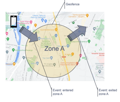
Use Cases
Logistics, Industry, Goods delivery and Fleet management: For example, a logistics company can use the Geofencing Subscriptions API to monitor high-value shipments in transit. By setting up geofences around key locations such as warehouses or transport routes, the company receives real-time alerts whenever a shipment enters or exits a designated area. This helps ensure the security and timely delivery of assets, while minimizing the risk of theft or misplacement.
Personal security: For example, a company providing employee safety services can use the Geofencing Subscriptions API to track the location of field workers in real-time. If an employee enters a restricted or hazardous area, the system can send an alert to supervisors or security teams, ensuring quick responses in case of emergencies and improving overall workplace safety.
Personalization and Marketing: For example, a retail business leverages the Geofencing Subscriptions API to send personalized offers to customers as they enter a specific shopping area. By triggering notifications based on the customer’s real-time location, the business can deliver location-based promotions, increasing engagement and driving sales while ensuring the accuracy of targeting through reliable, tamper-proof location data.
Location-Based Marketing: Enabling targeted marketing campaigns by sending notifications to users when they enter specific geographic areas.
Event Management: Monitoring the movement of attendees at events to ensure they remain within the event premises.
Benefits
Enhanced User Experience: Users benefit from more secure and personalized services, receiving timely alerts, relevant offers, and location-based notifications that improve convenience and engagement.
Improved Security and Safety: The real-time location tracking helps ensure the safety of individuals or assets by triggering alerts in case of deviations from expected locations, reducing the risk of theft, misplacement, or hazards.
Increased Operational Efficiency: Service providers gain the ability to monitor and manage assets, employees, or resources in real time, leading to better decision-making, quicker responses to critical situations, and streamlined operations.
Accurate, Tamper-Proof Location Data: The use of reliable, MNO-verified location data ensures the accuracy of location-based services, marketing, and security measures, fostering trust and confidence in the services provided.
Operational efficiency for the API customer (cost savings).
API Portfolio: Location Services
SubProject Wiki: Device Location
(incl. how to meet the team)
API Wiki: Geofencing Subscriptions
API Repository: Device Location
API Repository Status: Incubating candidate
API Status: Initial
API Version(s) and Release Date(s):
...
...
...